Utilities are using Airborne LiDAR for the inspection of power transmission lines. LiDAR (Light Detection and Ranging) is a remote sensing method used to examine the surface of the Earth by using light in the form of a pulsed laser to measure ranges to the Earth.
Airborne LiDAR is a dynamic, polar, and active multi-sensor system. Like radar, LiDAR is an active remote sensing technology but instead of using radio or microwaves it uses light. The LiDAR sensors work by emitting numerous narrow beams of near-infrared light with circular/elliptical cross sections, these beams reflect off the objects in their trajectories and return to the detector of the LiDAR sensor (pictured left).

Airborne LiDAR sensors are installed on a helicopter or drone for collecting data. Once activated, the Airborne LiDAR sensor emits light towards the ground surface, which returns to the sensor immediately after hitting an object, giving an exact measurement of its distance.
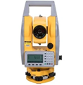
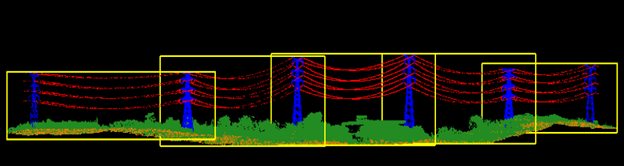
Routine inspection of power transmission lines is critical for securing uninterrupted distribution of electricity. Traditionally, this has been accomplished with ground-based inspection teams and methods that are very labor-intensive and time-consuming. In addition, calculating the distance between the sag of the transmission line and its proximity with some other object, such as a tree, often involves heavy equipment such as height measuring rods and/or theodolites (pictured right). This is a huge workload for the personnel who may be located in dense wilderness and/or hazardous terrain.
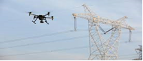
Today, many energy service providers are turning to the sky in order to conduct their surveys and analysis. Using automated UAV or drone technology (pictured left) that is equipped with LiDAR hardware has emerged as an effective alternative method for inspecting energy corridors and acquiring point cloud data.
Acquiring the point cloud data is only a small fraction of the full solution. Generating meaningful geospatial outputs requires post-processing and analyzation of the point cloud data, as hundreds of gigabytes of point cloud information is typically gathered. Once finalized, current clearance issues and projected imminent risks can be provided, allowing field teams to clear the hazardous areas more efficiently and effectively.